I-15/SR 78 Managed Lanes Connector and Woodland Interchange

SANDAG Caltrans SR 78 Corridor Improvements

The I-15/SR 78 Managed Lanes Connector and Woodland Interchange project is a collaborative effort between Caltrans, SANDAG, and the City of San Marcos to build new direct connector ramps between the existing I-15 Express Lanes and three miles of newly proposed express lanes on SR 78. An express lane, sometimes referred to as a high-occupancy/toll (HOT) lane, is a type of managed lane that helps alleviate congestion by prioritizing carpool, vanpool, and public transit. Express lanes may also be available for solo drivers who pay a fee.

Residential and economic growth along the east/west SR 78 corridor in the cities of Escondido and San Marcos has strained connections to and from I-15, a major north-south managed lanes system in San Diego County. This strain often results in increased traffic congestion and travel delays for residents and commuters. By extending the existing express lanes on I-15 and adding new direct connectors, the project would help improve connectivity and travel times, increase access to homes and jobs, and enhance the overall quality of life for residents and visitors in North San Diego County.

 
Map showing new eastbound and westbound managed lanes on SR 78 and direct connectors to existing I-15 Express Lanes showing south of the SR 78. Ramp, roadway, and undercrossing improvements run north-south over the SR 78 along Woodland Parkway and East Barham Road with sections running east-west along Rancheros Drive and East Barham Road. Also running along the east side of Woodland Parkway and East Barham Road area is a new Class II bike lane. To the northeast of the bike lane, there is a new westbound auxiliary lane between Nordahl Road and Woodland Parkway. SPRINTER light rail weaves along SR 78.

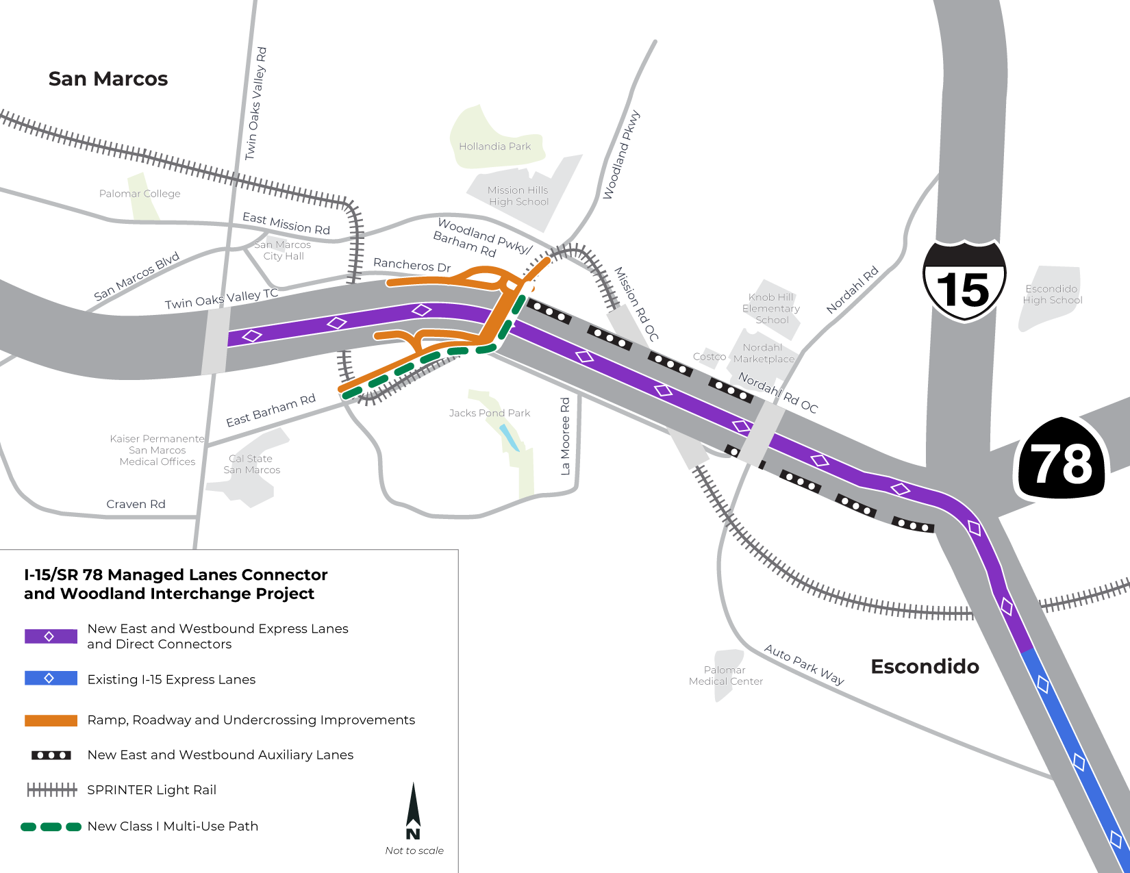
New express lanes on SR 78 in San Marcos will connect to the existing express lanes on I-15 in Escondido.

Key improvements proposed as part of the project include:

  • Building direct connectors between I-15 and SR 78
  • Extending three miles of express lanes in each direction on SR 78 between the I-15 interchange and San Marcos Boulevard
  • Adding a westbound auxiliary lane between Nordahl Road and Woodland Parkway/Barham Drive
  • Adding an eastbound auxiliary lane between Nordahl Road and I-15
  • Relocating the eastbound SR 78 on-ramp from Barham Drive
  • Widening and realigning Barham Drive from La Moree Road to Woodland Parkway
  • Replacing the Woodland Parkway undercrossing
  • Constructing a bike facility on Barham Drive/Woodland Parkway

Caltrans is the lead agency on this project under the California Environmental Quality Act (CEQA) and the National Environmental Policy Act (NEPA). This project is also a top priority among direct connector projects in the SANDAG Regional Plan. The project has an estimated cost of $490 million.

For more information, check our News page for project updates, subscribe to our email list, or contact sr78@sandag.org.

Project Timeline

The project completed its preliminary planning phase in 2017.

In October 2020, Caltrans released the Notice of Preparation (NOP) for the project. This kicked off a 30-day public scoping comment period. Early public feedback on the project helped the project team develop a comprehensive list of environmental topics to study, understand community concerns, and identify opportunities for improvement. The comment period ended on Friday, November 20, 2020.

The project team collected nearly 90 public comments which will be summarized in the project’s Draft Environmental Impact Report/Environmental Assessment (EIR/EA), expected to be released in mid-2025. Key themes included general impacts on traffic, traffic patterns on I-15 near the Valley Parkway on- and off-ramps, managed lanes operations and pricing, noise, landscaping, air quality, and proposed bike and pedestrian facilities.

This project is in the final stage of the environmental review process. We expect the draft environmental document to be completed by mid-2025. A final environmental document is anticipated to be completed in summer 2026.

The project is expected to enter the final design phase in 2026. The final design is expected to be completed by 2030.
Pending funding, we expect to begin construction on the project in 2030.

State and Regional Importance

The 2021 Regional Plan was adopted by the Board of Directors on December 10, 2021, and serves as our region’s long-term plan used to incrementally implement projects. SANDAG began development of the 2025 Regional Plan, the next four-year Regional Plan cycle, in late 2021.

Projects like the I-15/SR 78 Managed Lanes Connector and Woodland Interchange project are planned for and guided by the current Regional Plan.

The I-15/SR 78 Managed Lanes Connectors and Woodland Interchange project is a key component of the North County Comprehensive Multimodal Corridor Plan (CMCP). In early 2023, SANDAG and Caltrans released the Draft North County CMCP to the public.

A robust managed lanes system is a key feature of SANDAG's Regional Plan as well as the State of California's 2050 Transportation Plan and aims to connect all corners of our communities with a reliable overall transportation network.

Managed lanes, such as those along the I-15 corridor in San Diego County, are dedicated vehicle traffic lanes that alleviate congestion by prioritizing carpool, vanpool, and public transit. Managed lanes are also available for solo drivers to use with toll payment instead of traveling in busier all-purpose lanes. When paired with technology, this can help move more people, reduce traffic congestion, and increase transit ridership.

The I-15/SR 78 Managed Lanes Connector and Woodland Interchange project will serve as a critical connection between the existing managed lanes on I-15 and future managed lanes on SR 78.

Passed in 2013 and implemented in summer 2020, SB 743 changed the process in the California Environmental Quality Act (CEQA) used to measure the environmental impact of proposed projects. SB 743 requires measuring how many new miles of car travel a transportation improvement, or development project, will produce. Measuring vehicle miles traveled (VMT) changes transportation analysis from measuring the impact of a proposed project on drivers, to measuring the impact of driving on the community.

The I-15/SR 78 Managed Lane Connector and Woodland Interchange project is one of the first state projects to be evaluated under SB 743.